VORTEX-SE
Towards a better understanding of tornadogenesis and tornado environments in the Southeastern U.S.
Downdraft Processes - Data Evaluation from VSE 2017
IOP 1B, 27 MARCH 2017: QLCS with bowing segments, areas of weak low-level rotation, and leading isolated cells.
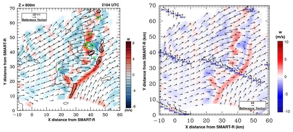
Left: Dual-Doppler low-level wind synthesis using SMART-R and ARMOR, showing low-level gust front, rear-to-front outflow, and areas of low-level rotation.
Right: Dual-Doppler low-level winds integrated with TTU stesonet data. Wind in m/s; Potential Temperature in K. Time-to-space conversion is 5 min.
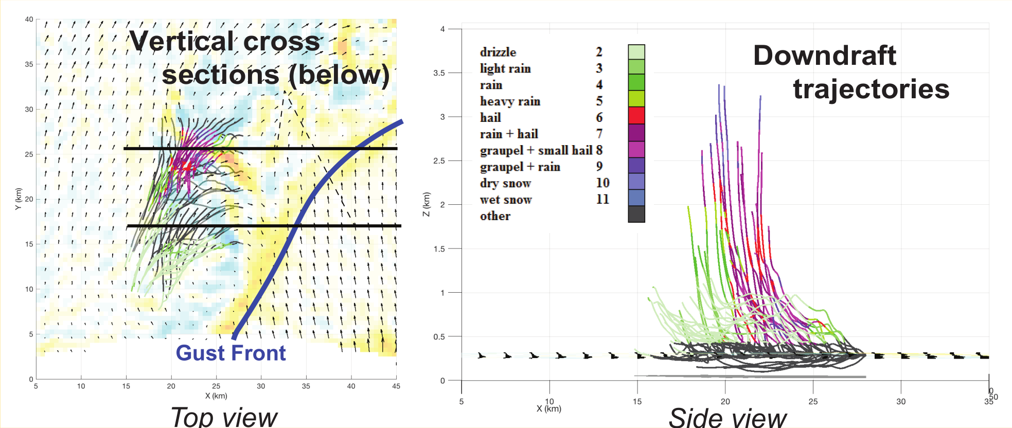
4D airflow is probed via calculations of parcel trajectories within the strongest downdrafts located near areas of low-level rotation. Trajectories are traced backward in time from 2108-2052 UTC. Among the tested regions, parcels display two primary downward vertical excursions during the 16 min integration period: 1) from z > 3 km (which could be higher, given the large amount of smoothing of Doppler velocities during objective analysis owing to the range from each radar), or 2) from much shallower depths, z < 1.5 km. Parcels descending from the higher altitudes contain larger rain and hail (dual-pol-retrieved) than those descending from lower altitudes.
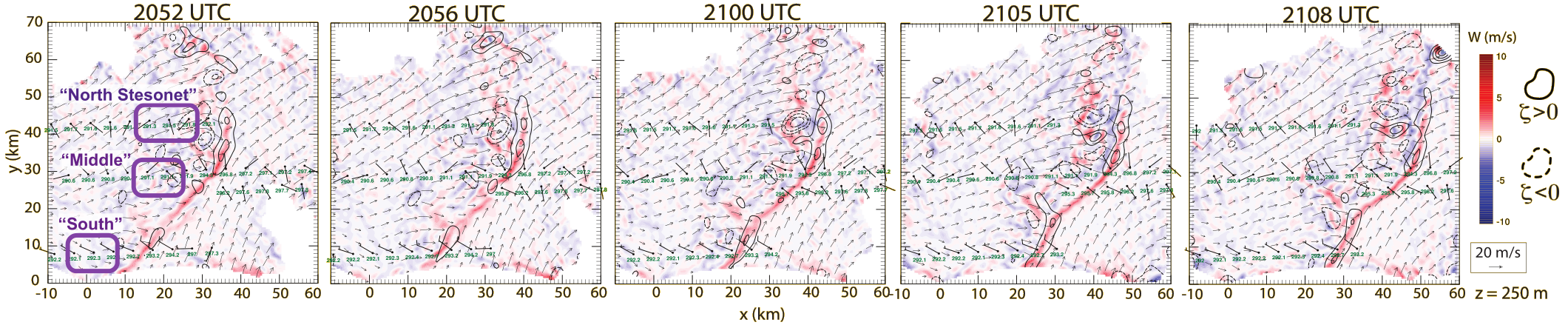
3D Dual-Doppler wind syntheses are performed using an upward integration of mass continuity. Radar velocity coefficients are assumed constant between the lowest radar beam and the ground to implement the lower BC (w = 0 m/s at z = 0 m). Wind syntheses illustrate updraft/downdraft structure and near-surface vertical vorticity located near the gust front. A few areas of enhanced downdraft are seen near the ground behind bowing segments of the line (.e.g, y ~ 20 km and ~40 km). Areas of positive and negative vertical vorticity are relatively weak, but these are likely underestimates of the true value owing to the relatively coarse resolution of the radar data. Winds and thermodynamic observations from the “stesonet” are shown (time-space corrected, using a mean gustfront motion, within a +/- 45 min window). These analyses indicate outflow air with a 5-7 K temperature deficit from the environment. Low-level winds observed by the stesonet typcially are significantly weaker and directionally-different from the dual-Doppler winds at the lowest common radar level.
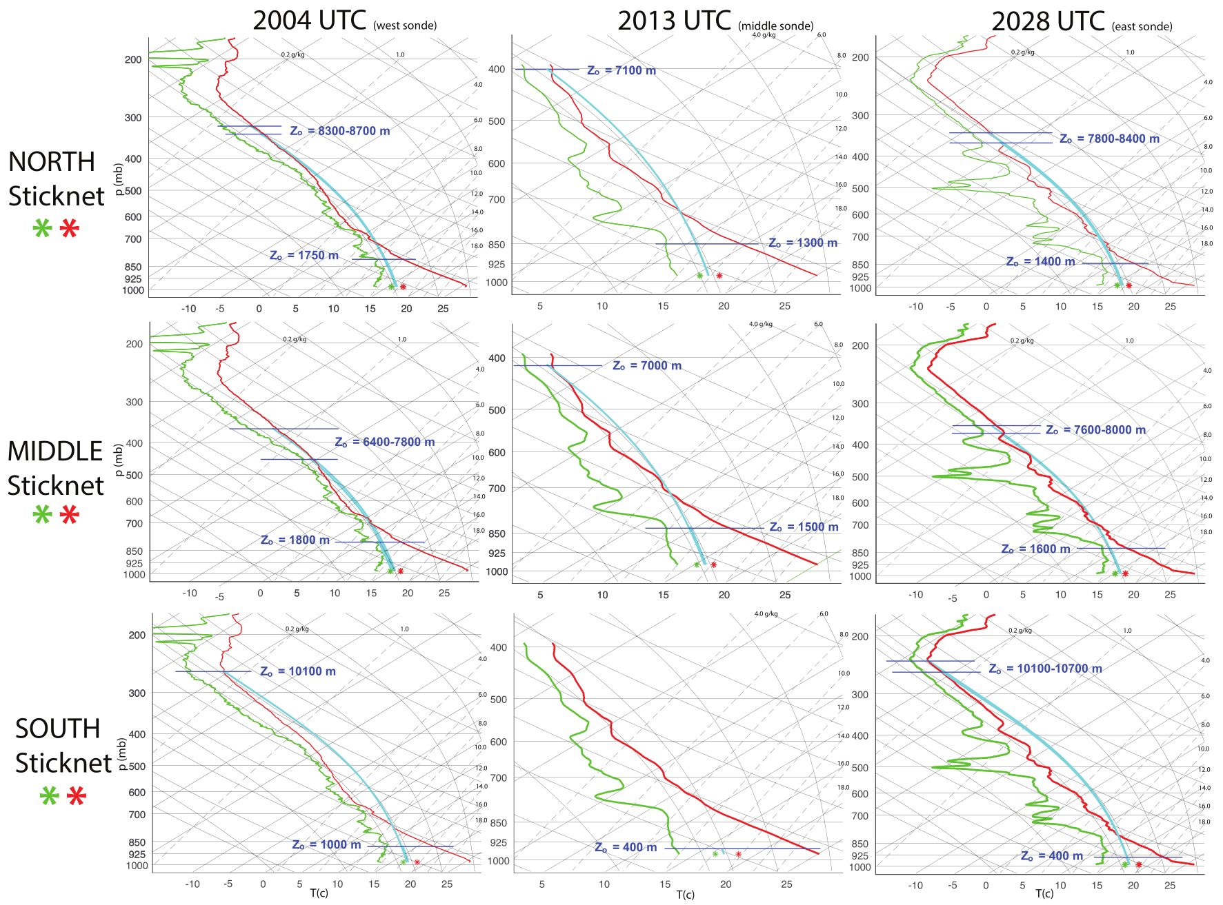
A combination of 3 proximity soundings in the near-storm inflow and 3 stesonet surface observations of outflow thermodynamics are used to constrain and pinpoint possible downdraft origin heights in the QLCS, and to address the sensitivity of these estimations to different environmental base states. Wet-bulb potential temperature is calculated for a variety of heights on each sounding and parcels brought down to the surface pseudo-moist-adiabatically for comparison with stesonet observations. This method utilizes typical parcel theory assumptions (e.g., neglects mixing of environmental/cloudy air, pressure gradient forces) to estimate downdraft/outflow thermodynamics, constrained by surface observations. A variety of possible downdraft origin heights are identified using this method. In general, downdrafts initiated from two main regions have thermodynamic properties that are consistent with surface observations: 1) from certain heights within the boundary layer (approximately 400-1800 m AGL), or 2) from various layers at upper levels (6.5-10 km AGL). Saturated air from mid-levels (~2.0 km - 6.0 km) is much colder at the ground than surface observations. Air originating from the upper most of the identified layers (z ~ 6.5-10 km) are positively buoyant for a deep layer aloft, suggesting that this air does not reach the surface as a downdraft (without significant downward-oriented pressure gradient forces present). Downdraft air with thermodynamics consistent with surface data from the “Middle” and ‘North” stesonet stations have similar origin altitudes; thus, there is only subtle outflow heterogeneity on the northern half of the dual-Doppler coverage region. However, parcel-theory-determined altitudes generally are lower for the “South” stesonet station.
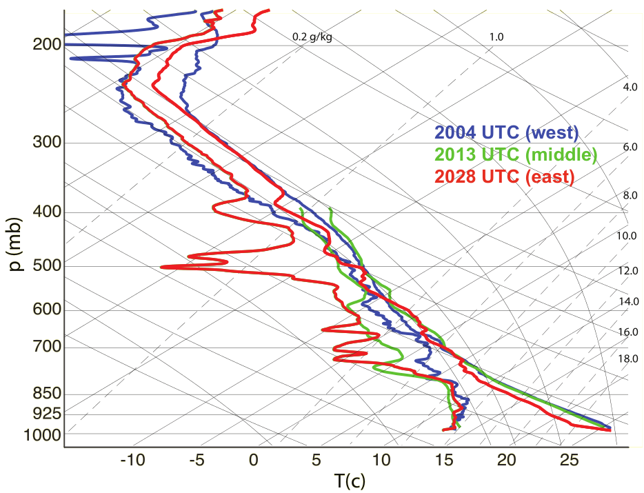
There is not an obvious sensitivity to the altitudes at which parcel theory predicts a surface temperature similar to stesonest observations for downward displaced air (altitude difference of only 100-400 m) based on which sounding is used. This is likely because mesoscale heterogeneity in the inflow is not particularly large. Indeed, temperature and vapor mixing ratios are qualitatively similar (differences < 3 K and 0.002 g/kg within the boundary layer and most of the tropospheric depth). The largest mesoscale variability comes from the moisture profiles between ~700-400 mb, where downward displaced air is too cold no matter which sounding is used.
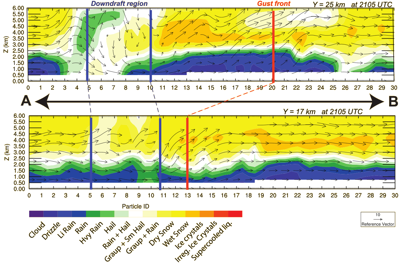
Vertical cross sections of retrieved dual-pol hydrometeor classification from the SMART-R radar. Slices include the approximate regions of downdraft measured with the trajectory calculations shown above. The deepest downdrafts are located in regions of mixed heavy rain, hail, and graupel. Shallower downdrafts contain a distribution of hydrometeors more consistent with typical stratiform rain (low-levels) and snow (aloft) conditions reported in trailing/leading regions of many QLCSs.
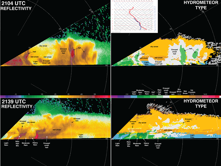
SMART-R reflectivity (left) and hydrometeor type (right) near dual-Doppler analysis time (top row) and later in storm evolution (bottom row), depicting evolution of hydrometeor type and distribution from predominantly graupel and hail to predominantly rain near/at the surface.