

One of the longest-running (1998-2008) CSWR projects (in collaboration with the National Center for Atmospheric Research / Atmospheric Technology Divistion (NCAR/ATD), ROTATE employs the DOW 6 and DOW 7 mobile radars as well as the Rapid-scan DOW. The underlying goal of the project is observe the process of tornadogenesis, tornado structure, tornado lifecycle, and tornado death. Major goals are to collect observations that will enable the evaluation of tornadogenesis hypotheses and to continue studies of tornado vortex structure and climatology. Using the Rapid-DOW system, in which six simultaneous beams scan the sky, permits tilt volumetric updates every 10 seconds, for the first time allowing for the resolution of rapid processes such as tornadogenesis and the evolution of multiple vortices.
The study region includes Oklahoma, Texas, New Mexico, Kansas and Nebraska. Preferred regions are western Oklahoma, the southwestern panhandle of Texas, and western Kansas due to the flat, treeless conditions, and good road networks. Dual-DOW observations permit the synthesis of vector windfields in tornadic and pre-tornadic storms at scales of 60-200 m (200-600 ft), over regions of 40-200 square kilometers (20-100 square miles.) Single Doppler observations occur at scales of 10-40 m (100 ft). Rapid update cycles of 30-70 seconds permit rapidly evolving phenomena to be studied.
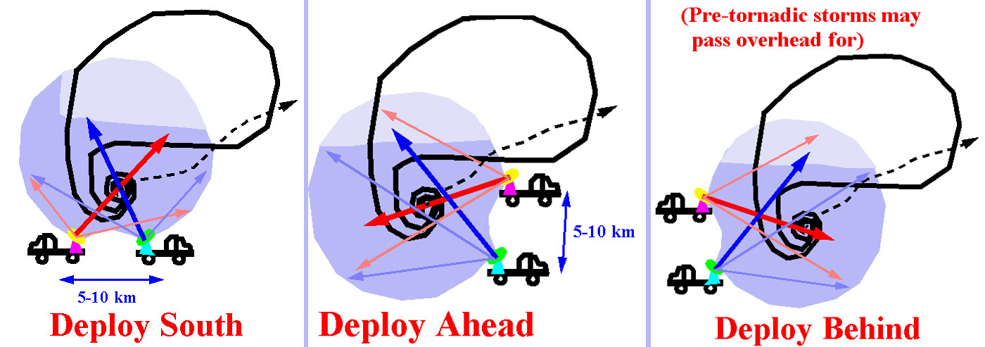
DOW deployment strategies focus on establishing a dual-Doppler lobe over the hook echo, rear-flank-downdraft region, and the tornado itself. Three main options, one for deploying south of a storm, and one for deploying ahead of a storm, and one for deploying behind a storm are illustrated schematically below. If the storm passes overhead during the "ahead" option, the radars scan the hook and rear-flank-downdraft region from behind.
![]()
 Go back